Time to give the apparently now-sound Yeoman a bit of a test – nothing too taxing, a 13 mile, low-level circular ride from Cliftoncote around a neighbouring property with the slightly unappealing name of Sourhope.
One of the reasons you need a decent map in the Cheviots is because nothing is pronounced as it looks: requests for directions to 'Sour Hope' would be met with blank looks...it is of course pronounced 'Sooroop'. There are many 'hopes' (or 'oops') round here (meaning hills ): Shorthope, Auchope, Naehope... Ok, that last one's a makey-up, just to see if you're awake.
But the names round here are fascinating - from whence comes Gloomy Cleugh, Murder Cleugh, Barbarous Stell and Foul Step - not to mention the Hanging Stone? A hard country, this!
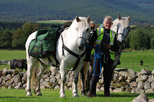
The three musketeers (and their riders) set off to have a look round Sourhope, which used to be an experimental farm for the Macaulay Institute, but is now tenanted.
The size of the steadings, remains of a mill, and the number of houses, suggests a past importance. Here, too, we saw much recent flood damage. We picked our way up a path by the Sourhope Burn (which flows into the Bowmont Water).
Well, there was a sort of path, but recent events meant the burn had overspilled, braided, formed pools and little oxbows so lots and lots of fording.
Great water practice for Shonagh's project pony Dougall... A few weeks before I set off they had come over for a training ride and it had taken a good fifteen minutes for him to strop himself over a tiny stream. He's obviously 'manned up' (borrowed terminology from my son Mark) and today he ploshed confidently through it all.
At the top of the burn we paused for lunch at the remote farm of Auchope, cooried right down on a cleft in the hills - a house obviously built to cope with the weather, rather than sited for views!
Here, as elsewhere in the Cheviots, we marvelled at the dykes which rise right up the impossibly steep hillsides - what skilled (and fit) men they must have been.
There was also of course a now-familiar stell - a circular stone sheepfold. The reason they are always round, Bill tells me, is because sheep are driven into them in snowstorms: because they're round, the sheep won't lie down but walk round and round, compacting the snow. If the folds were square, sheep would huddle down on the corners and be suffocated by the drifting snow.
A surprise up here was the large pheasant-rearing operation nearby...I am more used to seeing pheasants gleaning the barley fields back home and these seem harsh conditions for them to survive. But this area is one of the most sought-after shooting areas in Scotland, famous for its high birds. Over the next few days we were to see lots of pheasant activity: blocks of game cover crops on the hillside (looked very odd!) and acres of rearing pens.
We picked our way back to Sourhope along a landrover track past a small weather station ( a Macaulay left-over, perhaps?), past Dod hill ('dod' is fox in these parts and down the Kaim burn. Some frantic silage-making activity as we neared the farm - the wet summer proving a challenge everywhere.
A really interesting ride - and Yeoman was completely sound! Time to make tracks for England, then...
Subscribe to:
Post Comments (Atom)

Pleased to hear that yeoman is back to normal. yes the names are somewhat odd! Good luck for the next section Kate.
ReplyDeleteCheyenne
I remember being in the village of Sour hope in 1984. We dropped down from the Cheviot hills too early when completing the Pennine walk to Kirk Yetholm.
ReplyDelete