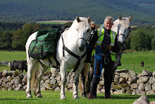
Numbers are becoming meaningless. How many miles have we covered today? Covered altogether? These are the questions asked by many folks we meet.
I don't know the answers- I'm relying on the GPS Traakit people to ultimately tell me, or I can of course retrace my steps on the maps and calculate it out.
Of much more interest is the state of the map when I've finished crossing that bit of territory. Depending on how creased, dirty, wet (pulped in the case of dear old Wigtownshire) I have an instant visual aide-memoire of the fun (or otherwise) we had there.
Yes, I have a fine map case (disintegrating though, due to my unathletic mounting and dismounting especially as the day wears on). But the nature of maps is such that you can guarantee in any day that it needs to be taken out, refolded, or worse- move onto another map altogether- all on the back of a moving horse and often in the rain. The current record is four maps in one day. No, we don't move at the speed of light, just happened to be lurking around the corners!
I haven't really experimented with electronic mapping so am not qualified to offer an opinion (DOESN'T USUALLY STOP YOU -DOOGS) but I would definitely miss my dog-eared, torn, damp and stained record of where we've been. Plus it's a handy place to jot down telephone
numbers, people's names and other memos to self...
It is a fundamental rule of horse travel, as in life, that 20% of your route will cause you 80% of your problems - and so it proved for Carol & I.
Being diligent sorts, Carol and husband Colin had checked out many of the routes we were to ride. Pressure of time meant they had to delegate one short section, a 'footpath' through Carrick Forest.
'it's fine' came back the report, 'we went through on the quad'. This has been added to the Long riders' Lexicon, along with gems like 'it's a bit soft' or 'a wee bittie steep'...! Quads of course move over the surface of the ground on broad tyres: ponies don't!
Doogs was running loose behind us when we came to this section, following us on April and Yeoman. We set off carefully down this section. Doogs was reluctant to follow, pacing first left, then right, but refusing to set foot on the 'path'.
He's such a wily old codger that when I saw what he was up to I immediately jumped off Yeoman, seconds before he sunk up to his belly in a bog. It took two or three goes for him to get himself out (and he's a strong horse).
Time for a rethink then, and an about-turn...due to recent forestry extraction there were a number of new tracks not marked on the map, but which ran out or abruptly changed direction, as they do.
At last we hit upon a track which led us down into the Stinchar Valley (through a field of donkeys - a complete surprise to all parties!) and we followed the river up to the charming village of Barr, which unlike most of the villages I have ridden through on this trip still has a shop, an excellent pub (we took over their car park) and a functioning phone box.
We also acquired a pilot through Changue Forest, young Daniel, who insisted on showing us the way on his bike in return for a couple of hunks of cake...had more cake been forthcoming I think we'd have him yet.
We don't half land lucky with our hosts: tonight we made it to Pinvalley and the charming Ann. As the skies were beginning to threaten she offered us the use of her trailer to sleep in (which is
housed in a large barn, along with her smart horses.)
We had reason to be more than usually grateful as we listened to the rain hammering on the roof that night. The only disturbance was the snoring of Lovely Horse no 3- I'd definitely be sewing corks onto HIS pyjamas...
Sunday, 16 August 2009
Subscribe to:
Post Comments (Atom)


No comments:
Post a Comment